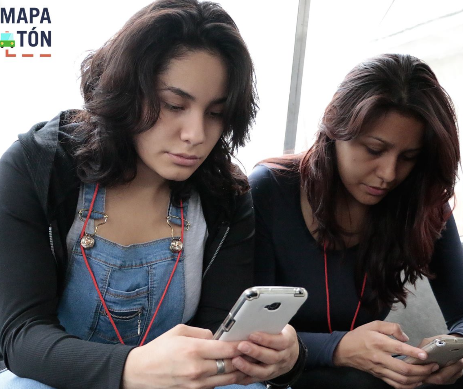
From January 29 to February 4, 2016, an experimental department of Mexico City crowdsourced nearly 4,000 residents who mapped their bus routes through a gamified app to provide local insights for a scalable, cost-effective solution to the city’s significant gap in transit data.
Source: Mapatón - Facebook
By Brooke Clark, Jessica Ryan, Evan Maki, Ximena Diaz Lopez, Michelle Yeung, and Dylan Clark
Problems and Purpose:
Over the past six decades, Mexico City's peseros, their privately owned buses, have seen a dramatic increase in demand. Today, they serve more daily riders than all other city-administered public transport modes combined. In 2016 alone, an estimated 30,000 peseros provided 14 million rides, highlighting their critical role in urban mobility (Phelon 2020; Paulin, Anthopoulos & Reddick 2017). However, Mexico City has faced significant barriers to effectively mapping its routes in order to offer riders reliable data.
The informal and dynamic nature of the pesero system, coupled with a lack of resources for traditional data capture prevented the government from mapping the system for decades. Until recently, commuters had to rely on informal word-of-mouth instruction, often resulting in long and unpredictable travel times. Efforts to integrate technology and community feedback into mapping these routes began in 2015, with the aim to enhance the efficiency of Mexico City’s transportation network.
Background History and Context of the Case:
City and Transportation Growth
In 2016, Mexico City covered nearly 1,500 square kilometres with sixteen administrative jurisdictions. In the past century, Mexico City has experienced exponential population growth from 3 million inhabitants in the 1950s to 21 million by 2015 (Kumar and Indu 2019). To meet its population’s mobility needs, the city has developed an extensive and multi-modal transportation network. However, the government administered public transport is unable to meet all of the city’s transportation needs so public transport administered by the private sector is concessioned.
Context of Peseros
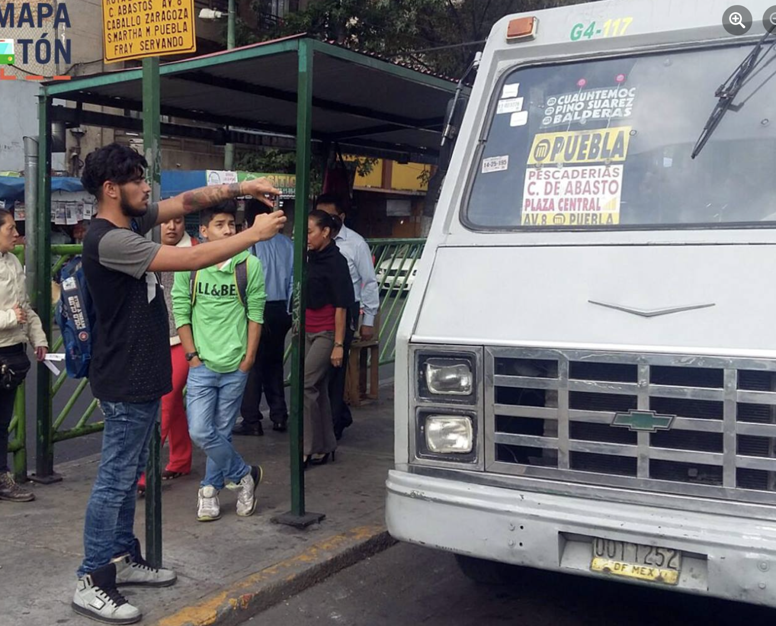
Peseros, a government-concessioned and privately run bus system, provide routes for travelers on a fixed fare. The original fare cost one peso, hence their name. They first emerged in 1952 when uncontrolled urban growth and development, a concentration of activities in a central zone, and a lack of planning drove demand for transportation (Roschlau, 1981). Initially offered as shared taxis on fixed routes (commonly called peso taxis), peseros operated in key corridors of Mexico City and fulfilled a public demand that was not met by the city (Roschlau 1981). In the 1980s, peseros filled service gaps, connecting travellers to the city’s trams, trolley buses, and metro lines (Roschlau 1981). Over time, the peseros transformed, increasing in size and in quantity and becoming an established transportation mode. They shifted from cars to vans, micro-buses, and buses. The peseros continued to operate with fixed fares and no official stops as the peso taxis did. In 2016 it was estimated that peseros met more than 65% of the transport needs of the more than 19 million mobile individuals of the city (Kumar and Indu 2019). Yet, without any set routes and an expanding fleet, creating maps of pesero routes has become a looming issue for the city.
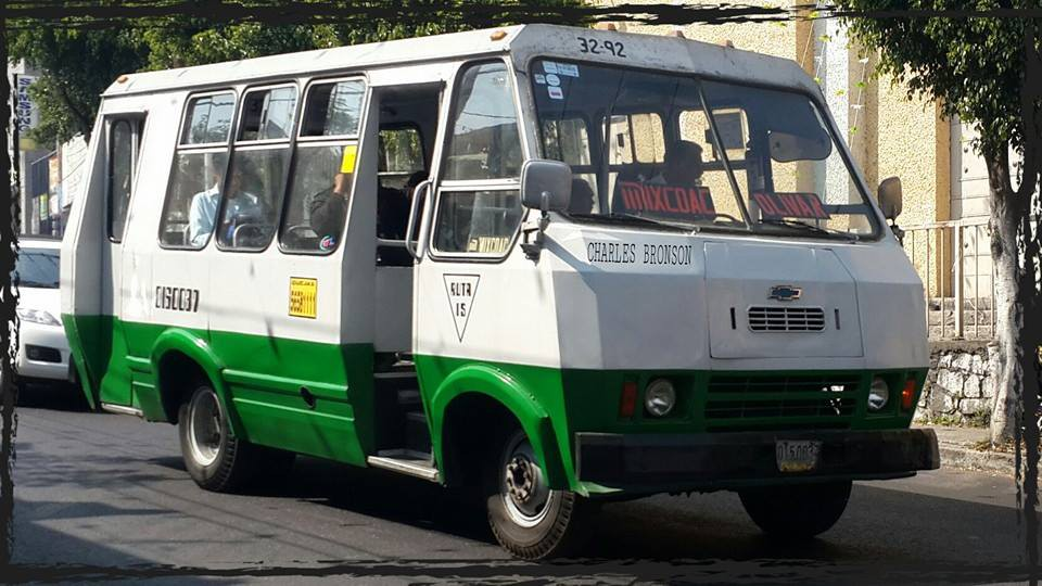
Figure 1: a pesero model in CDMX
source: Gobierno de Mexico
Context of Mapatón
During the mayoral election of 2012, Dr. Miguel Ángel Mancera ran on a platform to “foster civic innovation by visualizing platforms where government and civic society can collaborate and harness urban creativity” (Kumar and Indu 2019, p. 2). After his election, Mancera’s first step toward civic innovation involved hiring Gabriella Gómez-Mont, an accomplished artist, journalist, and documentary filmmaker. He tasked Gómez-Mont with leading a six-month project to facilitate collaboration between citizens and the local government. Her team created el Laboratorio para la Ciudad–commonly referred to as “the Lab”–a city department that had a mandate to use a data-forward approach to create a “Code for Mexico City” to solve problems. They recruited six programmers and hired 16 additional volunteers (Greenwald 2016).
In 2015, the Lab assembled 27 civil society organizations and 48 government agencies in their first Right to Mobility meeting. Here they discussed issues in mapping pesero routes and pioneered the idea behind the Mapatón project: harness citizen power to find a mapping solution. In late 2015 the Lab and its programmers created the Mapatón application, inspired by MIT’s Flocktracker app. This app allows the user to record transit routes via mobile phone GPS, the data from which fed into an open-source database.
Participants and Gamification
To earn points, players mapped complete pesero routes that had the Federal District as their origin or destination (Mapatón CDMX, 2016). The scoring system considered the origin, significance, and number of mappings already completed on a route. For any given route, the first five mappers would receive an equal amount of points. However, starting from the sixth mapping onward, the points gradually decreased (Mapatón CDMX, 2016). The app incentivized routes that were more difficult to map and non-peak riding times through special missions. For instance, between February 10 and February 14, 2016, ten additional tablets were awarded to the most active players who contributed significantly to mapping selected Modal Transfer Centres in the northern and eastern regions of the city.
Players could map individually or team up with family and friends to earn points. The points could be used to redeem cash prizes and electronic devices worth a total of 170,000 pesos (Mapatón CDMX, 2016). The three teams with the highest scores would receive additional cash prizes ranging from 10,000 to 30,000 pesos (Mapatón CDMX, 2016). Individual players could also exchange points for electronic devices and rewards.
Post-Mapatón Hackathon
To leverage the data generated by Mapatón, a local NGO called Integral Platform for Sustainable Development (PIDES) organized a three day Hackathon. The Hackathon brought together ten mentors with expertise in programming, geography, design, and other relevant fields to facilitate the work (OECD, 2017).
At the end of the Hackathon, participants presented their innovative ideas, the best of which were rewarded with prizes. The winning idea involved the use of SMS technology, allowing users–particularly those without smartphones–to send a text message to a designated number with their starting point and destination. In response, they would receive detailed information about available bus services, including routes, schedules, and other relevant details for their intended journey (Kumar and Perepu, 2019).
Organizing, Supporting, and Funding Entities:
The Lab was the principle organizing body behind Mapatón and was funded by the government of Mexico City. The cost of the Mapatón project was estimated to be 350,000 pesos, funded by the British Embassy in Mexico and the Hewlett Foundation (Kumar and Indu 2019). The initiative was supported by 13 different agencies who played various roles in the Mapatón project. Agencies who played key roles in the project included:
- Krieger Electronics–these consultants helped to create and maintain the application product and technology
- Secretary of Mobility of the City–administered city data and worked on the database
- PIDES Social Innovation–handled logistics and advised on citizen collaboration efforts
Participant Recruitment and Selection:
Participants were crowdsourced and the game was promoted on several social networks including Facebook, Twitter, and the official Mapatón CDMX site. To generate an open database of the pesero route mapping, the Lab participation needed broad and robust rider participation. Anyone over the age of 16 with a smartphone or tablet operating Android 4.1 or later could participate by downloading the Mapatón CDMX application (Mapatón CDMX, 2016). However, iPhones were not supported because of Apple’s stricter application approval process (Mapatón CDMX, 2016).
Methods and Tools Used:
Analysis Using Selected Frameworks
As a case study, Mapatón sits at the intersection of gamification, smart cities, and public participation. The project is significant for two key reasons: (1) it exemplifies how innovative avenues of participation can widen the capacity of both government and the public and (2) it produced results that could not have been achieved through more traditional mechanisms. This section will analyze the case of Mapatón through several theoretical lenses.
Gamification
Gamification broadly refers to the introduction of game-like elements to processes where they did not previously exist. Primarily, it is used as a tool to modify behaviour through a combination of extrinsic and intrinsic rewards (Hasan 2017). This tool has the potential to be beneficial in regards to public participation. Public participation is a vital aspect of democratic government, yet participation through official channels has seemingly declined over time. Thiel and Fröhlich argue that this decrease is not a symptom of a lack of interest in governance or its outcomes. Instead, they propose that the public has simply shifted to unofficial means of communicating their preferences, such as social media (2016). However, this lack of preference for official channels poses difficulties for government’s ability to accurately gauge public opinion, much less to rely upon public knowledge. Gamification presents a potential solution to this problem.
In the example of Mapatón, gamification provided clear benefits. By developing an app that incentivized, structured, and compensated participation, the Lab was able to draw on crowd knowledge in order to gather data that was outside normal government capacity. Although participants were initially drawn in by game elements and monetary rewards, they later became deeply invested in cooperating towards solving the mapping problem that affected their community (Sandoval-Almazan et al. 2017). The Hackathon held at the end of the project further extended the tactic of gamification. By offering prizes for solutions, the Lab incentivized participation. From simple data gathering, the project evolved into citizens making decisions about data. The choice to keep the data open source was an intentional invitation to cooperation.
Living Labs and Open Innovation
Relatedly, Mapatón is not only an interesting case in regards to gamification, but also touches on two concepts that originate from business theory: living labs and open innovation. A living lab is meant to allow responsive research that can enable inventive solutions to complex problems. The idea involves two key principles: open cooperation and real world testing (Sandoval-Almazan et al. 2017). A living lab co-develops its research through all stages of the process–from testing to implementation–and can flexibly respond as its hypotheses play out in practice.
Parallel to living labs is the idea of open innovation, which entails keeping data, and analysis of that data, available for any to access (Ibid. 2017). The high degree of accessibility in this approach allows for not only transparency, but also a greater variety of expertise to be involved; interdisciplinary, cross-sector collaboration can produce novel solutions. In relation to Mapatón, users were able to drive the direction of the project, due to the open approach favoured by the Lab. For example, the solution created during the Hackathon to enable route data to be transmitted by texts allowed users without access to smartphones to use their flip-phones to access mapping data. As another example, the data gathering itself relied on user expertise, which could never have been replicated by government monitoring. In both examples, public knowledge was leveraged cooperatively to identify and resolve obstacles.
Mapatón implemented theories of gamification, open innovation, and living labs to great effect. While these conceptual tools are rarely used in the context of city planning, Mapatón illustrates how effective they can be at building community capacity, creating connections between government and people, and constructively managing complex data. This case is an example that other local governments could look to for inspiration.
What Went On: Process, Interaction, and Participation
This section will analyze how Mapatón played out in practice. The degree and quality of participation will be considered through the various stages of the project. Not only is Mapatón an example of a robust participatory approach, but it also connects to the concept of smart cities. The case represents a real-world example of how participation and technology can be wedded to create new solutions to enduring urban challenges.
Arnstein’s Ladder of Participation
In her article, Arnstein identifies a series of rungs with which to categorize the quality of participation government facilitates. At the lowest end of the scale, government engages with citizens manipulatively or therapeutically, using people as justification for already decided policies rather than working with them as partners, whereas the highest levels of the ladder are citizen control and delegated power (1969). For Arnstein, more power in the hands of people means better participation. With reference to this framework, how can Mapatón’s level of participation be categorized?
For the data-gathering phase, Mapatón falls onto the “consultation” rung. Arnstein articulates that consultation can be a legitimate tactic, but only in combination with higher rungs on the ladder, lest it risk a purely decorative function (1969). One criticism of Mapatón might be that it limited the types of input possible. Another criticism might be that Mapatón allowed the city to simply outsource labour for data collection at a lower cost. However, the later stage of the project empowered citizens to make decisions about the gathered information, elevating the participation to the “partnership” rung. Further, the limited scope and budget were necessary in order for the project to succeed to the collective benefit of participants. While Mapatón did not go so far as citizen control, it was a healthy, efficient act of cooperation between government and the public.
Smart City
One other conceptual framework that connects to Mapatón is the idea of a smart city. The theory of smart cities evolved in response to the growing size and complexity of urban centres. In short, a smart city is one that uses widespread participation alongside technology to allow local governments to gather high quality data and make informed decisions that best fit residents’ needs (Johannessen and Berntzen 2016). Johannessen and Berntzen investigate how a smart city framework can be especially helpful for public transportation planning. Social learning and social capital can, through apps or other tech, empower people to make a modal shift, for example from car-oriented transit to mass public transit (2016). Mapatón represents a similar type of modal shift wherein riders created a new, responsive schema that transformed an informal transit network into something semi-formalized. As volunteers became increasingly organized, they began to participate actively in the planning of their city, whereas previously this aspect of the transit network was abandoned to private operators who lacked the resources for large-scale coordination.
Mapatón sits at the intersection of numerous exciting theories about participation, technology, and urbanism. Although imperfect, it illustrates the possibilities of tech to allow participation and co-decision making between people and their governments. In an era where government capacity has continuously degraded, as have levels of public participation, it is exciting to see how new technologies and theories of technological use can be harnessed for positive, efficient social change. Although brief in duration, Mapatón acts as both an example of what is possible generally and a specific example that could be potentially replicated and scaled to different urban contexts.
Case Evaluation and Discussion:
Gamification to Boost Engagement: Results
The Mapatón project demonstrates the promise of gamification in boosting civic engagement. Over the project’s 17 days 3,624 participants mapped of 4,110 pesero routes, yielding 709 unique routes after data cleaning (Big Bold Cities, 2018). The data included route path, length, starting and ending points, and the number of stops per route, although the stops were not geo-referenced and varied in number (Manuel, 2016). This map shows every unique route mapped, with colors indicating time required to transit from beginning point to end point.
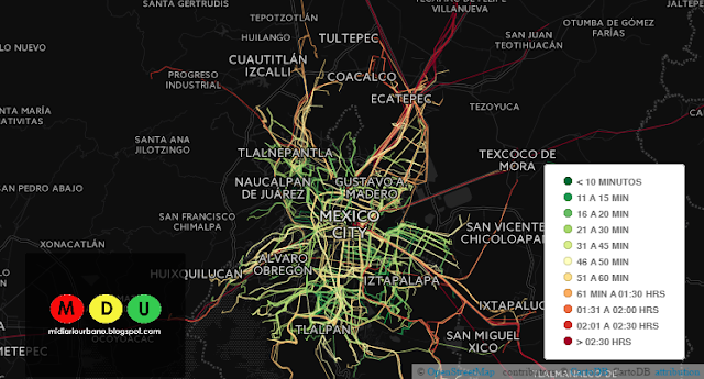
Image Source: (Manuel, 2016)
Participants mapped 51,308 kilometers in two weeks, equivalent to 475 days of traditional mapping (Kumar and Perepu, 2019). The Mapatón project budgeted was achieved around 350,000 Mexican Pesos, or about $20,000 USD, demonstrating the cost-effectiveness of gamification. The Mapatón app points system motivated participants to map a wide variety of unique routes across an incredibly large geographic area, even across state boundaries. An individual involved in the planning of the Mapatón project said, “gamification allowed us to attract people of all statuses and income levels…” (Paulin, Anthopoulos, and Reddick 2017). This demonstrates that gamification could solve one of the perennial issues in planning: How can planners attract a more proportionally representative population–considering spatial, racial, socioeconomic, and other characteristics–to be civically active and involved?
Open Innovation as a Means of Capacity Building: Results
The Lab’s key objective was to build capacity through citizen collaboration in a transparent, open data environment. In Mexico where institutional trust is low, a collaborative open innovation process, where every member of the project team has an equal voice and vote, can strengthen government-private and government-NGO capacities. The project adopted horizontal organizational structures, shared budgets, and inclusive decision-making processes that enabled more collaboration than traditional methods (Paulin, Anthopoulos, and Reddick, 2017). According to one interviewee in Paulin and Anthopoulos who was involved in the planning process, “we became friends and now have contacts in the different government organisations (2017).”
Mapatón had potential to reshape government and civil society relationships, whereby the role of government is more supportive and empowers outside organisations to generate new ideas and solve public problems. The United Nations Development Programme highlighted the project’s role in increasing and promoting civic engagement (UNDP, 2019).
The open innovation model not only improved the quality of the mapping data but also built government-citizen collaboration, contributing to a more resilient and adaptive public sector.
Mapatón–a Lack of Follow-up
Eagle-eyed readers may have noticed that this case study lacks primary source material. After mapping, the data wasn’t effectively used and the Lab was disbanded once Mayor Mancera left office. Most primary material relating to the project, including the original Mapatón website and the collected mapping data, is no longer hosted online or publicly available. After mapping the routes, the data was largely under-utilized aside from publishing the dataset (Manuel, 2016). This outcome raises questions. Given that Mapatón was a project aiming to foster civic engagement and build institutional trust, why would a participant of Mapatón engage in a similar initiative in the future, if their efforts had led to no tangible change or innovation in Mexico City? Such an outcome is also deleterious to the intragovernmental and government-private-NGO capacity building that was facilitated by Mapatón, particularly given that frequent government personnel changes have been identified as a significant issue affecting government capacity in Mexico City (Paulin, Anthopoulos, and Reddick, 2017).
Recommendations and Lessons Learned:
Participation Strategy Recommendations for Mapatón
For future Mapatón-like projects in Mexico City, this section introduces a series of key recommendations. These recommendations include more sustained engagement and follow-up, a strategic approach to data utilization, diversifying participation methods, building institutional trust, and capacity building and training.
Sustained Engagement and Follow Up
The project's initial success in data collection was significant but lacked sustained engagement and follow-up, which is crucial for the long-term success of participatory projects (Kumar & Perepu, 2019). With reference to Arnstein's “Ladder of Citizen Participation,” the project should have used continuous engagement to ensure that participants were not only informed, but actively involved in decision-making processes (Arnstein, 1969). This approach would not only maintain interest but also foster a sense of ownership and responsibility among participants.
Strategic Data Utilization
Despite the successful collection of extensive data in Mapatón, its application was limited (Phelon 2020; Paulin, Anthopoulos & Reddick, 2017). Echoing Fung’s insights on complex governance, future projects should have a clear plan for data use in decision-making processes to practically apply the collected information (Fung, 2006).
Diversifying Participation Methods
Mapatón heavily relied on Android smartphone technology, which excluded certain demographics (Paulin, Anthopoulos, and Reddick, 2017). In line with Cornwall’s exploration of diverse participation models, future projects should enhance inclusivity by offering multiple avenues for engagement, including offline methods, to accommodate a wider range of voices and perspectives (Cornwall, 2008). Diversification ensures broader participation across different socio-economic groups, leading to more representative and equitable outcomes.
Continuous Institutional Support
The post-Mapatón phase saw the dissolution of the Lab, highlighting the need for stable and continuous institutional support (Paulin, Anthopoulos, and Reddick, 2017). Drawing from Hooper’s research, to build and maintain trust, government entities must commit to long-term support of participatory projects and ensure transparent communication, balancing local needs with broader project goals (Hooper, 2020).
Enhance Participation Quality and Capacity Building
It is crucial to enhance the quality of participation through training and capacity building (Paulin, Anthopoulos, and Reddick, 2017). In accordance with Arnstein’s perspective on citizen participation, future initiatives should focus on educating participants about effective data collection, urban planning principles, and the project's broader goals, thereby moving towards higher levels of informed participation and empowerment (1969).
Broader Lessons for Participatory Planning
In the wake of the Mapatón project's insights, there are many take-aways that highlight the nuanced aspects of engaging communities in urban planning. Lessons from Mapatón include the effectiveness of gamification in participant engagement, the advantages of open innovation for collaborative problem-solving, the importance of balancing technological tools with human insights, and the need for adaptive project designs that respond to evolving challenges. These lessons stress the significance of maintaining a long-term vision, ensuring inclusivity and equity, and fostering interdisciplinary collaboration.
Mapatón’s use of gamification demonstrated its effectiveness in engaging a diverse participant base (Thiel & Fröhlich, 2016). Gamification can be a powerful tool in other participatory planning contexts, as it motivates and sustains participant engagement through its interactive and rewarding nature. However, it is crucial to balance the gamification elements with the seriousness of the planning objectives to ensure that the engagement remains.
The project’s open innovation model facilitated creative problem-solving and collaboration (Sandoval-Almazan et al., 2017). This model can be beneficial in other participatory planning projects, allowing for a wide range of solutions. While technology was a cornerstone of Mapatón, the project also underscored the value of human insight and local knowledge (Johannessen and Berntzen, 2016). In line with Bostrom's exploration of the ethical dimensions of technology, future participatory planning efforts should strive for a balance between technological tools and the nuanced understanding that residents provide (Bostrom, 2009). This balance is crucial to ensure that the technological aspects of the project do not overshadow the contextual insights of the community.
The ability of Mapatón to adapt to challenges was a significant strength, highlighting the importance of flexibility in participatory projects (Kumar and Perepu, 2019). This adaptability, as emphasized by Pritchett and Woolcock, is crucial in responding to the complexities of development projects, allowing for adjustments based on participant feedback and unforeseen challenges (2004). Such a design approach ensures that the project remains updated throughout its implementation, adapting to the evolving needs and circumstances of the community it serves.
Effective participatory planning should be guided by a long-term vision, with clear objectives and mechanisms for assessing impact, as emphasized in the Mapatón project (Kumar and Perepu, 2019). Biermann's work on planetary boundaries and governance provides a framework for understanding the significance of such a long-term vision and thorough impact assessment in shaping sustainable and effective participatory planning strategies (2012). This approach not only ensures that the outcomes of participation lead to meaningful and lasting improvements in urban environments but also makes impact assessment an integral part of the project.
Ensuring inclusivity and equity in participatory processes is crucial for the success of projects like Mapatón (Paulin, Anthopoulos, and Reddick, 2017). Klosterman's analysis of urban planning debates reinforces this point, highlighting the importance of designing participation methods that are accessible to all segments of the population, especially underrepresented groups (1985). Such inclusivity in participation not only leads to more equitable outcomes, but also ensures that the planning process reflects the diverse needs and perspectives of the entire community, making it more representative of the societal fabric.
The success of Mapatón was partly due to the collaboration across different fields and sectors (Kumar and Perepu, 2019). Future participatory planning initiatives should similarly embrace interdisciplinary collaboration to enrich the planning process and outcomes. Collaboration between different disciplines brings together a range of expertise, leading to more holistic planning solutions.
Project’s Global Impact
The Mapatón project's innovative approach has inspired similar participatory and technology-driven initiatives worldwide, demonstrating its significant impact in urban planning and public participation. In Belo Horizonte, Brazil, urban planning students engaged residents in mapping livability criteria, while in Nairobi, Kenya, researchers used GPS and smartphone data to map the city’s private van system, matatus. Additionally, in Colombo, Sri Lanka, the Mo-Buzz app for dengue prevention exemplifies how technology can facilitate public involvement in addressing urban challenges. These global examples underscore Mapatón's influence and showcase the transformative power of community engagement and technology in urban planning (Big Bold Cities, 2018).
Works Cited
Arnstein, Sherry R. 1969. "A Ladder of Citizen Participation" Journal of the American Planning Association 35(4): 216-224.
Big Bold Cities. (2018). A Small Group of Thoughtful, Committed Citizens. Big Bold Cities. https://bigboldcities.org/en/innovation/small-group-thoughtful-committed-citizens.html
Biermann, Frank. 2012. “Planetary boundaries and earth system governance: Exploring the links.” Ecological Economics, 81: 4-9.
Bostrom, Nick. 2009. “The Future of Humanity.” In: Olsen J. K. B., Selinger E. and Riis S. (eds) New Waves in Philosophy of Technology. London, UK: Palgrave Macmillan.
Brady, C., and Hooper, M. 2019. “Redefining engagement with socio-spatially marginalised populations: Learning from Ghana’s Ministry of Inner City and Zongo Development.” Urbanisation, 4(1), 9-28.
Cornwall, Andrea. 2008. “Unpacking ‘Participation’: Models, Meanings and Practices” Community Development Journal, 43(3): 269-283.
Fung, Archon. 2006. “Varieties of Participation in Complex Governance” Public Administration Review 66: 66-75.Gobierno de Mexico. (n.d.). La Evolución de los Transportes en la ciudad de méxico. El Mirador. https://elmirador.sct.gob.mx/sobre-ruedas/la-evolucion-de-los-transportes-en-la-ciudad-de-mexico-iii
Greenwald, Rebecca (2016). Q&A: Gabriella Gomez-Mount, Laboratorio Para la Ciudad (Part 1), www.metropolismag.com
Hooper, M. 2020. “The politics of participation in post-disaster planning: local needs and perspectives versus global aspirations in plans for Montserrat's new capital.” The Town Planning Review, 91(6): 577-600.
Johannessen, M. & Berntzen, L. Smart Cities through Implicit Participation: Using Gamification to Generate Citizen Input for Public Transport Planning (2016). Innovation and the Public Sector 23, 23-30. http://dx.doi.org/10.3233/978-1-61499-670-5-23
Klosterman, Richard E. 1985. “Arguments for and against planning.” The Town Planning Review, 56(1): 5-20.
Kumar, K.B.S, Perepu, Indu. (2019) Mapatón - A Success Story of Resolving the Public Transportation Issues in Mexico City with the help of Modern Technology Platforms, Collaborative Networks, and Citizen Participation. E-PARCC Collaborative Governance Initiative. Syracuse University. https://www.maxwell.syr.edu/parcc_eparcc.aspx
Manuel, J. (2016, April 16). Análisis del Mapatón CDMX. Mi Diario Urbano. https://midiariourbano.blogspot.com/2016/04/analisis-del-Mapatón.html
Mapatón CDMX. (2016). Frequently Asked Questions. https://web.archive.org/web/20170521111408/http://Mapatóncd.mx/docs/preguntas.pdf
Mapatón CDMX. (2016). Rules. https://web.archive.org/web/20170613163814/http://www.Mapatóncd.mx/docs/reglas.pdf
Mapping out bus routes in 17 days: Mexico City’s Experimental Lab (2019). UNDP.
Organization for Economic Co-operation and Development (OECD). Embracing Innovation in Government – Global Trends. https://www.oecd.org/gov/innovative-government/embracing-innovation-in-government.pdf
Paulin, A. A., Anthopoulos, L. G., & Reddick, C. G. (2017). Going Beyond Bureaucracy Through Gamification: Innovation Labs and Citizen Engagement in the case of “Mapatón” in Mexico city. Beyond Bureaucracy (pp. 133-149). Springer International Publishing AG. https://doi.org/10.1007/978-3-319-54142-6_9
Phelon, Anna (2020, July 10). How Mexico City Crowdsourced a Map of its Riotous Informal Bus System. Atlas Obscura. https://www.atlasobscura.com/articles/ted-mexico-city-crowdsourcing
Roschlau, M. W. (1981). Urban transport in developing countries : the peseros of Mexico City (T). University of British Columbia. Retrieved from https://open.library.ubc.ca/collections/ubctheses/831/items/1.0095353
Pritchett, Lant, and Michael Woolcock. 2004. “Solutions when the solution is the problem: Arraying the disarray in development.” World Development 32(2): 191-212.
Sandoval-Almazan, R., Ramon Gil-Garcia, J., Valle-Cruz, D. (2017). Going Beyond Bureaucracy through Gamification: Innovation Labs and Citizen Engagement in the Case of “Mapatón” in Mexico City. In: Paulin, A., Anthopoulos, L., Reddick, C. (eds). Beyond Bureaucracy. Springer Cham.
https://doi.org/10.1007/978-3-319-54142-6_9
Secretaría de Movilidad de la CDMX. (n.d.). Sistema de transporte colectivo metro. https://www.semovi.cdmx.gob.mx/storage/app/media/MI%20MAPA/Mapa%20MI%20CDMX%20STC_1222.pdf
Thiel, SK., Fröhlich, P. (2016). Gamification as Motivation to Engage in Location-Based Public Participation? In: Gartner, G., Huang, H. (eds). Progress in Location-Based Services. Springer Cham.
https://doi.org/10.1007/978-3-319-47289-8_20
